
Stretching along the coast from Marseille to Cassis is one of France’s most unique national parks: the Parc National des Calanques. Whether by sea or by land, the calanques are a must-visit if you have more than one or two days in Marseille. After two years here, I have explored many of the popular hiking trails through the calanques (though I’ve yet to visit them by sea… a huge dream of mine!). But despite my repeated visits, walking through the jagged, rocky paths of the looming limestone cliffs never ceases to be anything less than sublime. Here I’ve detailed several classic hikes that I’ve taken, all accessed by public transportation, thus ideal for tourists or non-driving people like me ! Be forewarned: not all of these hikes for the faint of heart… some of the trails are rocky, uneven, and have intense altitude changes, so be sure to take the proper precautions – water, decent shoes, more water, sunscreen. But if you are up for the challenge, pack a picnic and a swimsuit, and lace up your walking shoes! The calanques are sure to reward you with astounding landscapes and breathtaking beaches — all without ever leaving the city !
**Additional note: if you are exploring these hikes between June 1 and September 30, be aware that the park is more strictly monitored for fire prevention during the summer. Check here to make sure access is permitted before venturing out. If you want to check out all the possible paths and plan your own hikes, I highly recommended buying an official IGN map of the calanques. All trails and transportation options are extremely well marked and color coded!
Calanque de Sugiton
Length of hike: around 90 minutes to the beach, slightly more to return
Difficulty of hike: ✭✭✩✩✩
Superlative: Most versatile, best WOW-factor

Sugiton is probably the most classic of all the hikes in this post. It’s the hike the Tourism Office recommended to me when I first asked about accessing the calanques by public transportation. It’s got everything you could ask for: stunning vistas, turquoise water, a sunny beach, and the possibility for a little cliff jumping. Plus, a large majority of the trail is paved, making it one of the less technically challenging hikes. Full disclosure to give you an idea of the trek: I’ve done this hike in sandals – though I wouldn’t necessarily recommend it, especially if you’re not very surefooted.


To access the trailhead, take the line 21 bus from either Castellane or Rond Point du Prado metro stations to the last stop in Luminy. (On weekdays, I prefer the line 921 Jet Bus, the express version of the 21). From the bus stop, go up the hill towards the Ecole de Beaux Arts and you’ll see the entrance to the National Park ahead of you. Follow the red trail markers up the wooded path. Eventually the landscape will begin to change and become more rocky, and you’ll arrive at the paved road. Continue descending, following the red blazes to cut through the switchbacks. The best part of this hike for me, is when you turn the corner and suddenly, BAM! the Mediterranean in all of its turquoise glory. Shortly after, follow the signs for the beach (Plage) to continue descending to the water. If you’d like, you can also turn off the trail a bit earlier to climb up to the cliff’s Lookout Point before heading down the beach. Sugiton has a medium-sized pebble beach, which can be uncomfortable without proper footwear, or you can also relax on the large sunny rocks facing the open sea.
Loop to Calanques de Sormiou and Morgiou
Length of hike: 1 hour from bus stop to Sormiou beach. ~2 hours to to Morgiou port and back to civilization
Difficulty of hike: ✭✭✭✭✩
Superlative: Most striking views
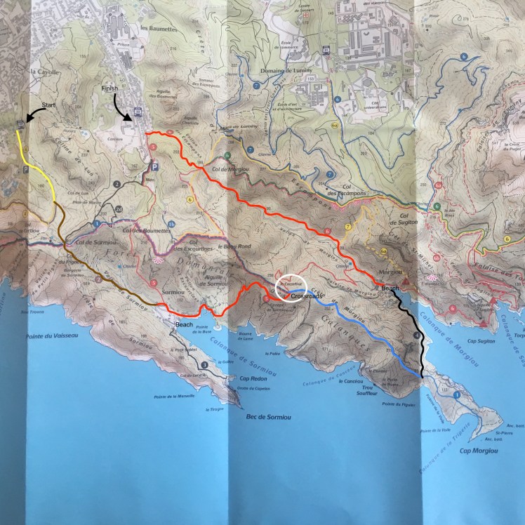
Sormiou and Morgiou are different from the more secluded Sugiton because they are both inhabited and accessible by car. Each has a mini port and are dotted with houses and cabins where (I presume) people live. As a result, the beaches themselves are a tad less magical than Sugiton – something about walking past a parking lot and a port-a-potty on the way to the beach sort of kills the romance of nature. However, the pedestrian-only trail between the two calanques takes you up and across the top of the cliffs and offers some of my all-time favorite views of the chain of calanques as it stretches down the coast.


There are multiple ways to access Sormiou by public transport, but I usually take the 23 bus towards La Cayolle from Rond Point du Prado and get off at the last stop: La Cayolle. When you get off the bus, you’ll continue straight down the street until you reach the Parking lot La Cayolle where you’ll see the trail head ! After entering the park, continue down the road until you see a trail veer off to the left. Start the climb, making sure to turn around at certain intervals for a sweet panorama of the dense city behind you. You’ll eventually arrive at the parking lot and beach of Sormiou. Take advantage of the comfortable sandy beach for your picnic or even a nice swim !
Once you’ve enjoyed Sormiou, it’s time to start the really fun part of the hike ! From the beach, you will follow the paths to the left to walk among the picturesque cabins. Continue to follow the red-marked trail up, up, and up until you reach the crossroad at the summit of the cliff. You can either choose to take the red path back down to the port of Morgiou, or the blue path which is slightly longer, but in my opinion has much nicer views, as it takes you to the far end of the cliffs towards the sea! I will admit to sometimes feeling lost on the seemingly endless blue trail – just keep going and eventually it will cross with a small trail marked with black blazes which will lead you down to the Morgiou beach. To finally rejoin civilization, follow the road and the red blazes until you find the bus stop line 22 Les Baumettes which will safely return you to Rond Point du Prado.


Calanque de Marseillevyre from Les Goudes/Callelongue
Length of hike: 1 hour from Callelongue to the beach at Marseillevyre
Difficulty of hike: ✭✩✩✩✩
Superlative: Least strenuous hike, Most interesting flora
I wrote about this hike last year!
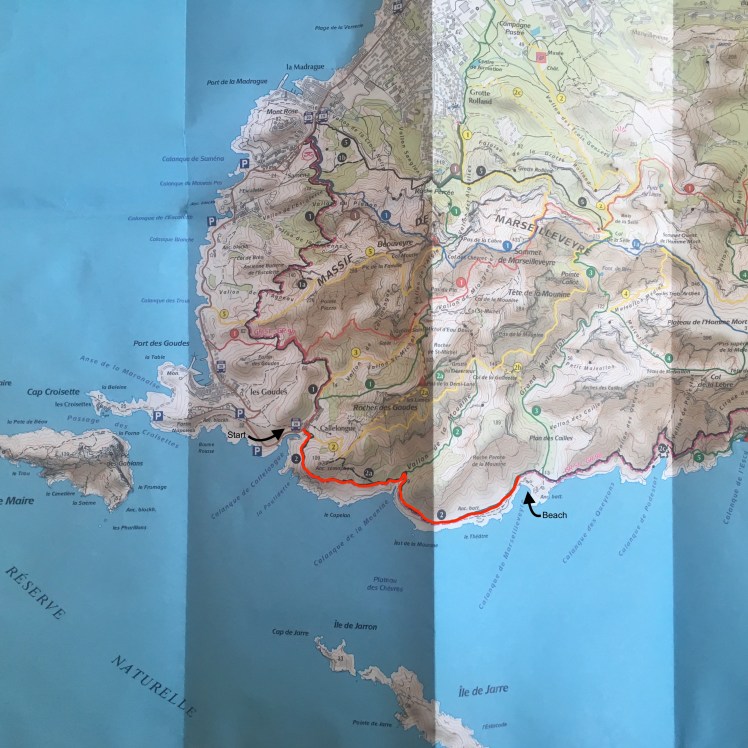
The Marseillais call the tiny fisherman’s village of Les Goudes ‘le bout du monde’ : the end of the world. And for good reason; this neighborhood all the way at the end of the coastline is extremely isolated and tranquil. Just up the road from les Goudes is the calanque de Callelongue, an even smaller community with just a few houses and cafés. But it’s from Callelongue that you can very easily depart on a short and non-strenuous hike to a lovely mixed sand and pebble beach, with a pleasant familial vibe and even a tiny restaurant that stays open until it runs out of fresh water for the day (seriously!).
Because the starting point of Callelongue is “at the end of the end of world, the bus journey there is rather long, but you’ll get to see quite a lot of Marseille on the ride. If it’s summer, you can opt to take the Maritime Ferry from Pointe Rouge to arrive at Les Goudes by boat ! Otherwise, take the route 19 bus from Castellane or Rond Point du Prado all the way to its terminus at Madrague de Montredon. From there it is possible walk to Les Goudes and Callelongue, but it will roughly double your hiking time. If you’re more pressed for time, take the number 20 bus through Les Goudes to the terminus at Callelongue. From there, walk to the right around the row of restaurants to the trail head. After a short rocky climb, the walk plateaus and the Mediterranean stretches in all directions before you! Follow the red and white trail markers for around an hour and you’ll eventually arrive at the beach where you can rest your feet and stop for a picnic and a swim! This hike is right at the beginning of the calanques, so the cliffs are not quite as massive and striking, and the landscapes are much more wild and filled with fascinating Mediterranean flora. It’s a different vibe, but certainly not any less impressive! See for yourself !


Coming soon: part 2 ! ❂

2 thoughts on “Hiking in Marseille’s calanques: part 1”